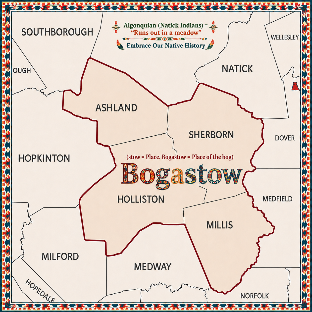
Bogastow History
Prior to 1674, the area South of Natick, but West of the Charles River (including wetland bogs) was referred to by colonists by its Natick Indian name of “Bogastow” (with several alternative spellings).
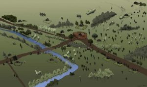
In the Algonquian language of the Natick Indians, Bogastow means “Runs out in a meadow.” Historically, the term was a place name for the entire Charles River Valley area stretching north and west between Natick and Medway. It was more specifically used by the Natick Praying Indian Village to denote the fertile meadows and floodplains lying west of the Charles river, an area highly valued by both early Indigenous communities and subsequent English settlers for its marsh grass. With their leader, Waban, about 100 Algonquian Indians, accompanied by Rev. John Eliot, established their village in 1651 (see next picture & second link at bottom). More and more colonists moved alongside this Christian Indian settlement each year as well as further south into modern day Sherborn by 1652. While the colonists mingled freely with the friendly Natick Praying Indians, not all Indians in the area were friendly.
During King Philip’s War, a broader conflict between Indigenous peoples and English colonists in New England from June 20, 1675, to April 12, 1678, hostile Indians made it as far as Medfield, killing 17 colonists, burning 33 homes, 2 mills, all 3 bridges leading over the Charles River as well as many barns. This war involved various Native American tribes, including the Wampanoag, led by Metacomet (who’s adopted English name was King Philip), and resulted in significant casualties on both sides. William Tilden, in his History of the Town of Medfield, writes that Metacomet had convened a large gathering of warriors at Wachusetts Mountain, 40 miles northwest of Medfield. But the trigger was the hanging in June, 1675, of three Wampanoags charged with murdering a Christianized and Harvard-educated Indian, John Sassamon, after Sassamon warned Plymouth’s officials of a pending Wampanoag rebellion. At the trial the officials produced an Indian witness who identified the three. Reverend John Eliot, (dedicated Cambridge-educated missionary and translator of the Bible to Algonquin) wrote,
“We were too ready to think that we could easily suppress the flea, but now we find that all the craft is in catching them, and that in the meantime they give us many a sore nip” (see last link below).
On the ruined bridge from Medfield to Sherborn, the Native-American, known as James-the-Printer, left a note on the Medfield side warning the settlers thus:
“Know by this paper that the Indians that thou hast provoked to wrath and anger will war these twenty-one years, if you will. There are many Indians yet. We come three hundred at this time. You must consider that The Indians loose nothing but their lives, you must loose your fair houses and cattle.”
Immediately after this attack, the Native Americans under Metacomet fled to Millis where they held a grand feast. This spot is marked by “The King Phillip Trees,” which are two hundred year old trees protected by the Millis Historical Society. The next day, on February 22, the Native American forces led an offensive against the Fayerbanke Palisades at Boggestowe Farms, which are in present-day Millis. This attack was repulsed, as well as a second attack, which occurred on May 6.
“Bogastow, ” and a few less common spellings, can be seen on many historical landmarks and organizations sprinkled in our region:
- Bogastow Brook, Sherborn
- Bogastow Brook Road, Sherborn
- Bogastow Farm Project, Millis
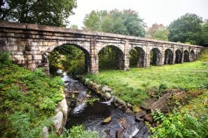
- Bogastow Viaduct, Holliston (on the rail trail, most famous landmark in Holliston)
- Bogastow Brook Road, Holliston
- Bogastow Brook, Holliston
- Boggestowe Fish and Game Club, 47 Ridge St, Millis
- Bogastow Circle, Millis
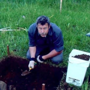
- Bogastow Farm’s Stone House discovered in Millis, 2005
- Bogastow Meadows, Millis (40 acres of town owned fields)
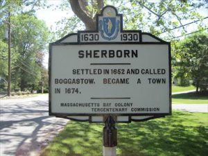
- “Boggastow” on the Sherborn historical sign, North Main Street / Rt. 27 coming from Natick (see next photo)
- Boggastowe Farm, Pepperell, MA (former residents of Bogastow area)
- Boggestow Ski Club Bethlehem, NH (created by a group originally from the Bogastow area).
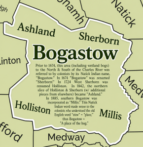
In 1674, the Bogastow area was incorporated as the town of “Sherborn” by the Mass General Court. Holliston was still part of Sherborn at that time known as “West Sherborn” until 1724 when it was incorporated as “Holliston.”
In 1842, the northern slices of both Sherborn and Holliston were combined with slices from Framingham and Hopkinton to form Ashland. Ashland wasn’t entirely carved from the Bogastow area, but its southern side was. Near the center of Ashland, these same Algonquian Natick Praying Indians established a Village they called “Magunkaquog” in about 1659. Reverend John Eliot was the colonist Pastor assigned to the Natick Praying Indians in 1651 and we see Elliot Street named after him on the South side of Ashland which was all Bogastow area along with Fruit Street where the Warren School is today. In 1885 the southern part of Bogastow was incorporated as “Millis.”
This Natick Indian word was shortened and reinterpreted by early colonists (commonly done in those days producing old words with different spellings) because the old English word for “place” was “stōw.” Thus to the early colonists, Bogastow was “Place of the bog,” which fittingly described that wetlands area.
It’s fascinating to follow Millis Historical Society President Paul La Croix’s 2005 discovery of the Stone House remains and artifacts at Bogastow Farm, Millis. Paul has given many talks and even written a book on the “The History of George Fairbanks’ Stone House at Bogastow Farms.” Read more: https://share.google/90cDqcENBw5VacTHD
Read about the Praying Indian Village & Bogastow’s founding:
https://www.natickhistoricalsociety.org/first-praying-indian-village
Read about King Philip’s War in Bogastow:
https://woodworth-ancestors.com/resources/king_philips_war.htm